Symbology 6 min read

Altitudes and minima

MSL vs AGL, QNH, transition altitude, DA vs MDA — the numbers that keep you alive.

Every number on a chart is referenced to something. Altitudes are given above mean sea level ( ) — your altimeter reads them when set to the local . Heights in parentheses, like (200), are above ground level ( ) — that is what the runway "sees" beneath you.

The three altitude references

  • MSL (ft) — altitude above sea level, read on the altimeter with QNH set.
  • AGL (ft, in parentheses) — height above the airport or terrain.
  • (FL) — used above the with standard pressure 1013 hPa / 29.92 inHg.
Profile view of a real plate
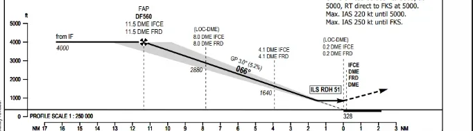
The profile view of the Frankfurt ILS 07C plate: level at 4000 ft until the FAP, then down the 3.0° glide path — every step is an MSL altitude, the (numbers) in the minima are AGL heights.

DA vs MDA

On a precision or approach ( , ) you descend on a continuous glide path to a Decision Altitude ( ): at that single point you decide — land or go around. On a non-precision approach ( , , ) you descend to a Minimum Descent Altitude ( ) and level off until you either see the runway or reach the .

What AIP plates print instead: OCA, OCH and VM(C)

European plates do not print a DA — they print (OCH) , the Obstacle Clearance Altitude (Height) . That is the lowest altitude/height at which the procedure still guarantees clearance from terrain and obstacles — the number the state surveyor computed, nothing more.

Your DA or MDA is derived from it : the operator takes the published OCA(H) and adds margins — aircraft and crew requirements, regulatory minimums (a ILS can never go below 200 ft above the threshold, even if the OCA is lower), company policy. -style plates do that work for you and print DA(H) directly; AIP plates print the raw OCA(H) and leave the margins to the operator. Either way: your minima can never be lower than the OCA . In the sim, treat the printed OCA as your floor.

Below the OCA(OCH) columns, minima tables carry a row labelled (C) OCA (OCH )Visual Manoeuvring () . That is the minimum for flying the instrument approach to one runway, then circling visually to land on another. The height is referenced AAL — Above Aerodrome Level , because while circling you care about the ground under the airport, not a single threshold. The VM(C) row exists even on straight-in approach plates — it is there for the day you break off and circle.

Minima table of the London City plate
A real AIP minima table — London City ILS 09: OCA(OCH) per aircraft category, in two rows for different missed-approach climb gradients — a steeper climb buys a lower OCA. The VM(C) row is 'not applicable' on this plate.

Climb gradients buy lower minima

Some minima tables do not give you one OCA but several — each tied to a missed-approach . Procedure design assumes the missed-approach obstacle surface rises at a nominal 2.5% from the point; where terrain sticks up into that surface, the OCA goes up with it. If your aircraft can outclimb the surface, the state may publish alternative OCA rows for steeper gradients — the 2.5% figure is always published, the steeper options are extras.

Minima table of the Innsbruck plate
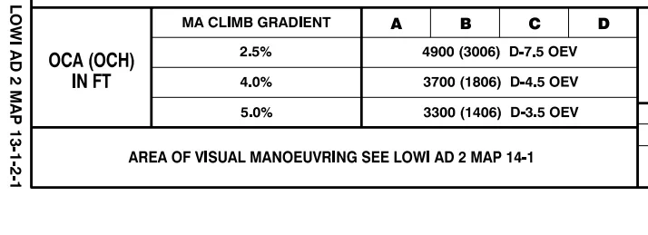
The minima table on the Innsbruck LOC DME EAST plate — one OCA per missed-approach climb gradient: 4900 ft at 2.5%, 3700 ft at 4.0%, 3300 ft at 5.0%. The missed approach point moves with it: D-7.5, D-4.5 or D-3.5 OEV.

Innsbruck is the extreme case: at the standard 2.5% the OCA is 4,900 ft; a 5.0% go-around buys 3,300 ft — 1,600 ft lower. Note that the missed approach point itself moves (D-7.5, D-4.5, D-3.5 OEV): the steeper your climb, the further down the valley you may continue. Lido-style minima tables print the same idea as a column header like " 4.5%" — GA meaning go-around gradient. The FAA system assumes 200 ft/NM (about 3.3%) unless the chart notes a higher required climb.

Two conversions worth memorizing:

ft/NMgradient [%]×61ft/minGS [kt]×gradient [%] \mathrm{ft/NM} \approx \mathrm{gradient}\ [\%] \times 61 \qquad \mathrm{ft/min} \approx \mathrm{GS}\ [\mathrm{kt}] \times \mathrm{gradient}\ [\%]

So 2.5% at 140 kt groundspeed is roughly 350 ft/min. And one caveat: a published gradient above 2.5% is a requirement, not a suggestion — real-world rules make the operator verify the aircraft can actually deliver it engine-out at the expected (a twin only has to demonstrate 2.1% single-engine in approach configuration). In the sim nothing checks this for you — it is a briefing item, not something the will flag.

Visibility and RVR

Minimums always come in pairs: an altitude AND a visibility. (Runway Visual Range) is measured along the runway — in metres on ICAO/Jeppesen charts, in feet on FAA charts (e.g. "RVR 2400"). A plain number like "800" or "1/2" is statute visibility or metres depending on the chart publisher.