Header, briefing strip, plan view, profile view, minima — learn the five building blocks of every approach chart.
Every approach plate, whether Jeppesen or government-style, answers the same questions in the same order: Where am I? What do I fly? How low may I go? What if it goes wrong? Once you know the layout, you can brief any approach in under two minutes.
The five building blocks
All five examples below come from the same chart — the real Frankfurt ILS 07C plate from the German AIP .
Header
The top band: who published the chart, its document index and the effective date. "AD 2 EDDF 4-2-9" is the chart's address in the AIP — aerodrome section (AD 2), airport EDDF, page 4-2-9. Jeppesen plates also put the airport name and procedure title up here; on AIP plates those sit one band lower, inside the briefing strip .
The top band of the Frankfurt ILS 07C plate: publisher (German AIP), document index 'AD 2 EDDF 4-2-9' and effective date 10 JUL 2025.
Briefing strip
The most important strip on the page: airport name and procedure title, the frequency table, airport elevation and magnetic variation — everything you set up before the first fix . On AIP plates the approach navaid box (ILS frequency, identifier, course) sits just below at the top of the plan view ; Jeppesen keeps it inside the strip.
The briefing strip: 'Frankfurt/Main ILS X CAT II & III or LOC RWY 07C' on the right, the frequency table in the middle, elevation 363 ft and VAR 4° E on the left.
Plan view
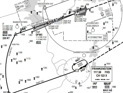
The approach seen from above: the final course, fixes with their altitudes, feeder routes, the missed-approach track, holding patterns, terrain elevations and the MSA circle around the navaid. This is the map you fly.
The plan view: final course 066° past the FAP to the MAPt, terrain spot heights around it, and the MSA circle (5000/2400) centered on the Frankenstein VOR at bottom right.
Profile view
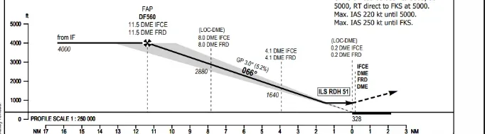
The same approach from the side: level at 4,000 ft until the final approach point , then down the 3.0° glide path to the threshold. The missed-approach instruction is printed where the profile ends — the procedure you fly if the runway never appears.
The profile view: level at 4000 ft to the FAP (DF560), then the 3.0° glide path down to the threshold — 'ILS RDH 51' marks where the glide crosses 51 ft above the runway.
The minima table: OCA(OCH) values for ILS CAT I, CAT II/III and the LOC-only procedure, plus the distance-to-threshold and rate-of-descent tables.
The briefing flow
Pilots read the plate in a fixed order: title → frequencies → navaid and course → minimums → plan view (fixes and altitudes) → profile → missed approach procedure. The Chart Explorer on this site walks you through exactly this flow on annotated real plates — and the symbols inside the plan view get their own article: Symbols and abbreviations .
Watch out
The most misread element is the altitude restriction line: an altitude with a line UNDER it is a minimum ("at or above"), a line OVER it is a maximum ("at or below"), and lines on both sides mean "exactly at". Mixing these up busts your altitude restrictions.